First of all, get hold of some maps of the coast to locate the various places that we visited on the fieldtrip.
Digital options:
- Digimap for Schools - we have a subscription to this service - this is the best option - ask your teachers for a login and password and you can create PDF maps
- ArcGIS Online - also has analytical tools such as heat maps. For this you'll need to geo-locate your questionnaires
- Stamen: Watercolor and Toner maps - these provide a nice attractive map for front covers, but the Toner maps can also be useful for marking on data, or adding other features.
- Field Papers - produce your own atlas essentially....
Paper options
- Ordnance Survey maps are available in the department for most areas of the UK
There are also some more local maps of the coastline, including a useful map which takes OS data but produces a strip map which runs along the coast. These were for sale from shops in Cromer, so if you're planning to head back to finesse your data collection or get some more photos then keep an eye out for them.
Sunday, 9 October 2016
Tuesday, 20 September 2016
Norfolk Wildlife Trust blog
This may be worth keeping an eye on as an additional secondary resource.

The blog explores some of the work of the Norfolk Wildife Trust.
2016 marks the 90th anniversary of the work of the Norfolk Wildlife Trust, the first in the country.

The blog explores some of the work of the Norfolk Wildife Trust.
2016 marks the 90th anniversary of the work of the Norfolk Wildlife Trust, the first in the country.
Norfolk Coast: an AONB
An AONB is an Area of Outstanding Natural Beauty.
Definition:
An Area of Outstanding Natural Beauty (AONB) is exactly what it says it is: an outstanding landscape whose distinctive character and natural beauty are so precious that it is in the nation’s interest to safeguard them.
There are 46 AONBs in Britain (33 wholly in England, four wholly in Wales, one which straddles the English/Welsh border and eight in Northern Ireland) and they cover 18% of our countryside.
AONBs are designated in recognition of their national importance and to ensure that their character and qualities are protected for all to enjoy.
They are living, working landscapes, much loved and valued by all who enjoy them. They are powerful symbols of our national pride: places of motivation, inheritance, excitement, pleasure and profit. The flora, fauna, history and culture of our AONBs’ lowland heath, wild moor, towering peaks, dramatic gorges, sheer cliffs, gently rolling hills, sandy beaches, spectacular cliffs, quiet coves, rocky shores, sand dunes, saltmarsh and shimmering estuaries ensure they remain Landscapes for Life.
How might the status of the Norfolk Coast as an AONB affect the way that it is managed?
Could that lead to conflicts between some of the people who use the land?
We actually visited the area during Outstanding Week, when AONBs are celebrated.
Pictures by Mr. Parkinson....
Do you have any good ones to share? Pass them on to your teacher please...
Cley next the Sea - some feedback
We started our field visit at the new Simon Aspinall Visitor Centre at the Cley Reserve. The weather was really damp, and it was torrential rainfall for most of the time we were there, although we did vote to actually brave the rain and head out onto the reserve.
Here's some nice feedback from the Cley visitor team on our efforts...
Thanks for the hospitality, and the good coffee that the staff and some students enjoyed from the cafe. Recommended on a sunny day...

Here's some nice feedback from the Cley visitor team on our efforts...
Thanks for the hospitality, and the good coffee that the staff and some students enjoyed from the cafe. Recommended on a sunny day...

Sunday, 18 September 2016
Tuesday, 6 September 2016
Digimap for Schools - now with aerial photography...
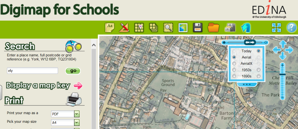
Digimap for Schools now contains a wonderful new addition that many of you have asked for over and over again – aerial photography!
The aerial photography shows magnificent detail and clarity - it's cloud free for all of Great Britain, something you won't get anywhere else! You can now compare and fade Ordnance Survey maps, historical maps and aerial photography with our new enhanced Map Chooser (shown). It's simple to use and offers maximum flexibility.
We've also added new learning resources to accompany the aerial photography. Be inspired with ideas such as using aerial photography to introduce learners to travel, transport and trade or discuss marks we humans leave on the landscape that can be seen in aerial imagery. Both excellent ideas to get you started with aerial photography.
To make you get the most out of this new addition to Digimap for Schools, we've created a short introductory video which explains the difference between Aerial and AerialX, the info tool for discovering exact dates the aerial photography was flown in your area of interest and a map key showing the patchwork of years stitched together to form this seamless dataset.
And of course there is a revised Help section on How to .... fade between map types.
Here's the video, and more videos and webinars are on the Digimap for Schools YouTube channel.
Here's the video, and more videos and webinars are on the Digimap for Schools YouTube channel.
Subscribe to:
Posts (Atom)