Saturday, 21 March 2026

Against the Tide

Living in Norfolk I am never too far from the sea, and erosion is a regular feature of local news programmes.

The Look East evening news programme mentioned a documentary that has been put together by the news team, exploring the region's issues with coastal erosion.

It's called 'Against the Tide' and can be viewed on ITVX.


Saturday, 9 March 2024

King Charles III path


There was good news for walkers this week with the opening of a new stretch of a proposed path which will run right around the coast of Britain. 

This is an area that has been out of bounds for years, as it runs through the Sandringham Estate. I lived in Snettisham for twelve years, and was often frustrated that at Wolferton the path petered out and came well inland away from the coast.

It was featured in the local paper, the EDP, and also on BBC News.  I look forward to following the path this coming summer to give it a go.

I've been down to Peter Scott's lighthouse many times and followed the path for part of the way, but it was always incomplete between King's Lynn and Heacham.

The trail is rather remote as it leaves King's Lynn... all the way to Snettisham. You'll want the wind behind you as well... 

The trail website is here.


Sunday, 17 September 2023

Coastwise in North Norfolk


One of our local papers had a story on a project called Coastwise.

There is more detail on the project here.

A video explaining the scheme, which is described as a coastal transition.


Over the next 100 years, it is predicted that over 1,000 homes will be lost to erosion in North Norfolk. Erosion will impact whole communities by threatening businesses, roads, footpaths, and utilities such as sewage, water and electricity. It will also affect our wellbeing, beach access and heritage assets such as churches, lighthouses, listed buildings, and much more.

The consequences of erosion are profound and require advanced planning to transition to being more prepared. Coastwise will involve working together in North Norfolk to develop nationally useful practical actions, plans and policy, funding and finance options.

Action needs to be taken now to explore how local authorities, communities, individuals, and national government can best work together to prepare and plan for coastal erosion.

The FAQs page here, along with some prepared questions could make a really useful resource for students to interrogate.
There's also a Photobook of examples.

And a film from Hemsby


Friday, 19 May 2023

Life on the Edge


New on iPlayer as of a few minutes ago is this 27 minute documentary on events at Hemsby on the Norfolk coast.

Worth a watch.

The residents of Hemsby don't want to leave, but their houses are on the edge of a cliff. This is their story of surving one of the most dramatic cases of UK coastal erosion.


Saturday, 24 October 2020

Sunday, 9 October 2016

Cromer work

For students to refer to...


Cromer Work by GeoBlogs on Scribd

What is Controlled Assessment?

Controlled Assessment forms part of your GCSE studies. It allows you to get ahead of the game, and secure a good percentage of your final mark before it comes to the written examination. The coursework guide which you were handed, and which is included in a previous post on this blog, provides the details on how to access these marks.

The new GCSE specifications are going to assess students in a slightly different way, so this is the last year of the 'old' Controlled Assessment.

It is important that you make the most of your time in the lessons between now and the hand in date, which will be outlined by your teachers. There is more detail in the Specification document if you, or your parents, would like to find out more.
Good luck with the creation of your finished piece of Controlled Assessment....

Options for mapping the coast

First of all, get hold of some maps of the coast to locate the various places that we visited on the fieldtrip.

Digital options:

- Digimap for Schools - we have a subscription to this service - this is the best option - ask your teachers for a login and password and you can create PDF maps

 - ArcGIS Online - also has analytical tools such as heat maps. For this you'll need to geo-locate your questionnaires

- Stamen: Watercolor and Toner maps - these provide a nice attractive map for front covers, but the Toner maps can also be useful for marking on data, or adding other features.

- Field Papers - produce your own atlas essentially....

Paper options

- Ordnance Survey maps are available in the department for most areas of the UK

There are also some more local maps of the coastline, including a useful map which takes OS data but produces a strip map which runs along the coast. These were for sale from shops in Cromer, so if you're planning to head back to finesse your data collection or get some more photos then keep an eye out for them.

Tuesday, 20 September 2016

Norfolk Wildlife Trust blog

This may be worth keeping an eye on as an additional secondary resource.

The blog explores some of the work of the Norfolk Wildife Trust.

2016 marks the 90th anniversary of the work of the Norfolk Wildlife Trust, the first in the country.


Norfolk Coast: an AONB

An AONB is an Area of Outstanding Natural Beauty.

Definition:

An Area of Outstanding Natural Beauty (AONB) is exactly what it says it is: an outstanding landscape whose distinctive character and natural beauty are so precious that it is in the nation’s interest to safeguard them.


There are 46 AONBs in Britain (33 wholly in England, four wholly in Wales, one which straddles the English/Welsh border and eight in Northern Ireland) and they cover 18% of our countryside.

AONBs are designated in recognition of their national importance and to ensure that their character and qualities are protected for all to enjoy.

They are living, working landscapes, much loved and valued by all who enjoy them. They are powerful symbols of our national pride: places of motivation, inheritance, excitement, pleasure and profit. The flora, fauna, history and culture of our AONBs’ lowland heath, wild moor, towering peaks, dramatic gorges, sheer cliffs, gently rolling hills, sandy beaches, spectacular cliffs, quiet coves, rocky shores, sand dunes, saltmarsh and shimmering estuaries ensure they remain Landscapes for Life.

How might the status of the Norfolk Coast as an AONB affect the way that it is managed?
Could that lead to conflicts between some of the people who use the land?

We actually visited the area during Outstanding Week, when AONBs are celebrated.

Pictures by Mr. Parkinson....

Do you have any good ones to share? Pass them on to your teacher please...


Cley next the Sea - some feedback

We started our field visit at the new Simon Aspinall Visitor Centre at the Cley Reserve. The weather was really damp, and it was torrential rainfall for most of the time we were there, although we did vote to actually brave the rain and head out onto the reserve.
Here's some nice feedback from the Cley visitor team on our efforts...

Thanks for the hospitality, and the good coffee that the staff and some students enjoyed from the cafe. Recommended on a sunny day...


Tuesday, 6 September 2016

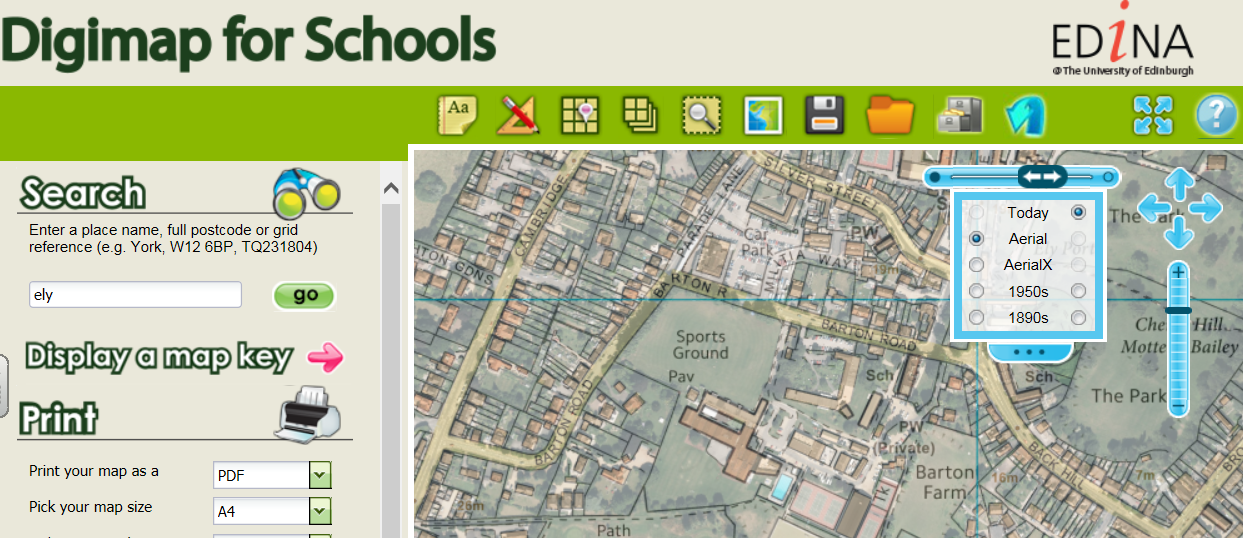
Digimap for Schools - now with aerial photography...

From the letter received this morning by subscribers....


Digimap for Schools now contains a wonderful new addition that many of you have asked for over and over again – aerial photography!
We are thrilled at the addition of this new data, kindly donated by Getmapping Plc.
The aerial photography shows magnificent detail and clarity - it's cloud free for all of Great Britain, something you won't get anywhere else!  You can now compare and fade Ordnance Survey maps, historical maps and aerial photography with our new enhanced Map Chooser (shown).  It's simple to use and offers maximum flexibility.
We've also added new learning resources to accompany the aerial photography.  Be inspired with ideas such as using aerial photography to introduce learners to travel, transport and trade or discuss marks we humans leave on the landscape that can be seen in aerial imagery.  Both excellent ideas to get you started with aerial photography.
To make you get the most out of this new addition to Digimap for Schools, we've created a short introductory video which explains the difference between Aerial and AerialX, the info tool for discovering exact dates the aerial photography was flown in your area of interest and a map key showing the patchwork of years stitched together to form this seamless dataset.  
And of course there is a revised Help section on How to .... fade between map types.


Here's the video, and more videos and webinars are on the Digimap for Schools YouTube channel.


Saturday, 3 September 2016

Building / repair work on the sea front at Cromer

These display boards were up for the last few years along the front at Cromer…
The work is now nearly complete… a few final things going on the last time I visited during the summer break...
Cromer Work by GeoBlogs on Scribd

Mapping our Shores

We will also be able to make use of this resource as a SECONDARY data source.
It is a mapping project by the National Trust.

It explores how the land is used around the coast, and 


See the Geographical magazine article for the full details..

A Secondary data source is one which has not been collected by you personally.

What's happening here? Part 2

6th December 2013 - another storm surge...


And ongoing repairs in 2014…

Image: Alan Parkinson

What's happening here?

Storm Surge
9th November 2007


How could the impacts of an event like this be reduced?

Student Booklet

This booklet is being given to you at the start of the new term to help you formulate your plans, and guide you through the next few months.